Since we began the writing and dissemination of these weekly news pieces and information bulletins, we’ve had many occasions to talk of the extraordinary wildlife in the Tsavo Conservation Area.
Tsavo is home to such a diverse selection of the wild world’s weirdest and most wonderful that writing those articles has been very easy, and incredibly enjoyable. There is, of course, more to Tsavo than it’s wildlife, however.
It is called home by many human communities, those of us at the Tsavo Trust including. But it is also the site of some of the natural world’s most incredible topographical spectacles. In this article, we wanted to highlight five sights that are especially worth seeing if ever you are to visit here.
The Yatta Plateau
The Yatta Plateau (pictured as the title image) is the first of many entries on this list that are caused by pre-historic volcanic activity. It is an icon of Tsavo’s skyline, running its western border and, at points, alongside the Athi River.
The Yatta Plateau is a ridge of elevated land that runs 290 kilometres from its start point at the Ol Doinyo Sabuk mountain. It was caused by the eruption of Ol Doinyo Sabuk and stands as testament to the world’s longest ever flow of lava.
At points, the Yatta Plateau rises over 100 metres above neighbouring lands. It’s a dominating spectacle and is equally useful as a point of reference for safari-goers as it is for our ranger teams, both aerial and ground, as they monitor wildlife for conservation purposes.
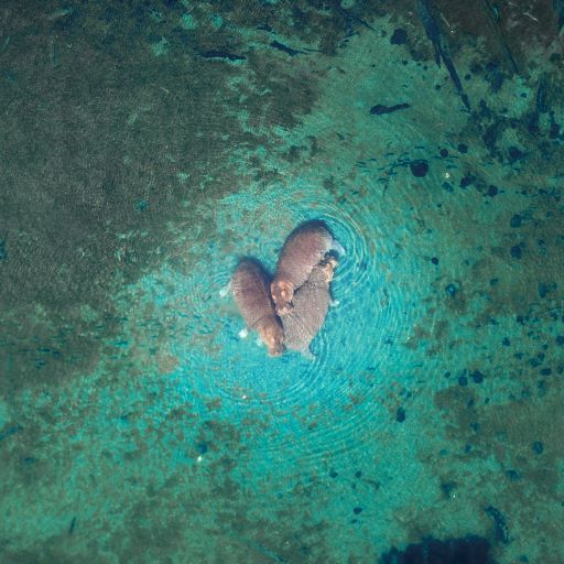
Mzima Springs
The crystal clarity of Mzima Springs is an important tourism draw for the Tsavo Conservation Area. Located in the Tsavo West, and around 48 kilometres from Mtito Andei, Mzima is fed from an underground reservoir beneath the Chyulu Hills.
The percolation of the water, before it arrives at Mzima, gives the springs an almost unbelievable transparency and, after two kilometres of downstream journeying, that water again descends underground. The isolation of Mzima gives it an almost mystical quality that definitely augments it as an attraction.
It is a truly beautiful spot and worthy of its plaudits in that regard. However, what deserves greater attention with regards to Mzima’s importance to Tsavo is its importance for researchers.
The mirage-like apparition of clear water amongst dry shrub and volcanic hills attracts hippopotamus and crocodiles. The clarity of that water allows researchers a unique insight into the behavioural patterns and society-building interactions of these water-dwellers.
Shetani Lava Flows
The snaking band of a blackened, almost flat surface might, from afar, resemble the raised ridge of a modern-day roadway. On closer inspection, however, the Shetani flow is very obvious as the memory of a volcanic eruption.
Littered with obsidian and absented of most wildlife and vegetation, Shetani evokes hellish, edge-of-existence descriptions. Shetani, perhaps unsurprisingly, means devil in Swahili.
The flow is 8 kilometres long, 1.6 wide and 5 metres deep. It was only created 240 years ago and is an awe-inspiring illustration of the blanketing, destructive power of an active volcano’s eruption.

Formed of the Galana River’s passage over (you might have guessed it) volcanic rock, Lugard falls is situated south-east of Tsavo’s national parks. The water’s passage through the unbending, volcanic rock has shaped it into a series of flattened ledges.
The drop following has created a gorge that adds an echoing effect to the cascading water. It is a popular sight that can be reached by hiking trails and, as most waterfalls do, the sight of it evokes thoughts of time’s passage and the smallness of human lives.